Thermal Imagery with aerial drones in Cold and Hot Climates
Welcome to the exciting world of thermal imagery and aerial drones! Imagine soaring high above, capturing invisible heat patterns in cold tundras or hot deserts with precision and efficiency. In this blog post, we will delve into the advantages, challenges, and success stories of using aerial drones for thermal imaging in extreme climates. Join us as we explore the fusion of cutting-edge technology and environmental exploration like never before!
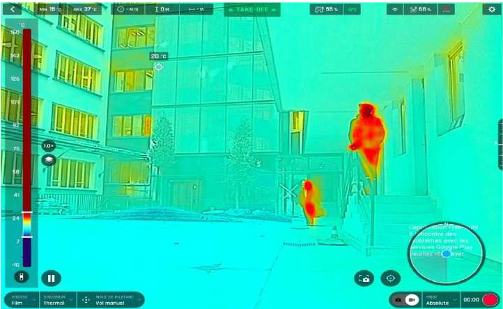
Thermal Imagery and Aerial Drones
Thermal imagery and aerial drones have revolutionized the way we perceive our surroundings, offering a bird's eye view coupled with detailed heat mapping capabilities. By harnessing the power of infrared technology, drones can detect temperature variations that are invisible to the naked eye. This innovative combination allows for efficient monitoring of environmental changes in both cold and hot climates.
Aerial drones equipped with thermal cameras provide invaluable data for various industries such as agriculture, construction, search and rescue, and even wildlife conservation. The real-time insights gained from thermal imaging help professionals make informed decisions quickly and accurately.
The ability to capture high-resolution thermal images from above offers a unique perspective that was previously unattainable without costly equipment or helicopter flights. With the advancements in drone technology, accessing remote or hazardous areas has become safer and more cost-effective than ever before.
Advantages of Using Aerial Drones for Thermal Imaging in Cold and Hot Climates
Thermal imaging with aerial drones offers a range of advantages when it comes to surveying in extreme temperatures. In cold climates, drones equipped with thermal cameras can identify heat loss in buildings, locate missing persons or animals in snowy terrain, and even monitor ice conditions for safety. This technology is invaluable for search and rescue operations where time is critical.
In hot climates, aerial drones can detect overheating electrical components before they fail, spot wildfires early on for faster response times, and assess the efficiency of solar panels by detecting temperature differentials. The ability to cover large areas quickly and access hard-to-reach locations makes drones ideal for thermal imaging tasks in both cold and hot environments.
With the capability to capture high-resolution thermal images from above, drone operators can analyze data more efficiently than traditional methods. Additionally, using drones reduces the need for manual inspections that can be dangerous or time-consuming.
Different Types of Thermal Cameras Used with Aerial Drones
When it comes to thermal imaging with aerial drones, the type of camera used plays a crucial role in capturing accurate data. There are various types of thermal cameras that can be mounted on drones, each with its own set of features and capabilities.
One common type is the radiometric camera which measures temperature variances across an image, providing detailed heat maps for analysis. Another option is the uncooled microbolometer camera, known for its durability and cost-effectiveness while still delivering quality thermal images.
For more precise measurements, some professionals opt for cooled infrared detectors which offer higher resolution but come at a higher price point. Additionally, there are dual-sensor cameras that combine both thermal and visual imaging for enhanced situational awareness during flights.
Choosing the right thermal camera depends on factors such as budget, project requirements, and desired image quality. It's essential to select a camera that aligns with your specific needs to maximize the benefits of using aerial drones for thermal imaging purposes.
Importance of Proper Training and Certification for Drone Pilots
When it comes to utilizing aerial drones for thermal imaging in cold and hot climates, the importance of proper training and certification for drone pilots cannot be overstated.
Operating a drone equipped with thermal cameras requires specialized skills and knowledge to ensure accurate data collection and analysis. Pilots must understand how to interpret thermal imagery correctly, navigate varying weather conditions, and follow safety protocols diligently.
Having certified drone pilots on your team not only enhances the quality of data you obtain but also minimizes the risk of accidents or errors during flights. Certification demonstrates a pilot's competence in flying drones safely and effectively, giving clients peace of mind that their projects are in capable hands.
Investing in training programs for drone pilots is an investment in the success and reliability of your thermal imaging operations. By prioritizing proper education and certification, you set your team up for success in delivering high-quality results consistently.
Case Studies: Successful Applications of Thermal Imagery with Aerial Drones in Cold and Hot Climates
Imagine a team of researchers using aerial drones equipped with thermal cameras to study the behavior of polar bears in the Arctic. With this technology, they can track the bears' movement patterns and monitor their health from a safe distance.
In hot climates, agricultural experts are utilizing aerial drones to detect irrigation issues in crops through thermal imaging. By identifying areas that require more water, farmers can optimize their irrigation practices and improve crop yield.
Search and rescue teams have also found success using thermal imagery with drones in both cold and hot climates. In snowy terrains, drones can locate missing individuals by detecting body heat signatures, while in deserts, they help find lost hikers by spotting them against the cooler ground.
These case studies demonstrate the diverse applications of combining thermal imagery with aerial drones across various environments.
Potential Challenges and Solutions for Using Aerial Drones for Thermal Imaging in Extreme Temperatures
Navigating the challenges of using aerial drones for thermal imaging in extreme temperatures requires expertise, preparation, and advanced technology. Despite the potential obstacles that come with operating drones in cold and hot climates, there are solutions available to ensure successful outcomes.
By understanding the impact of temperature on drone performance and utilizing appropriate equipment such as battery heaters or cooling systems, professionals can mitigate issues related to extreme weather conditions. Additionally, investing in proper training and certification for drone pilots is crucial to maximize efficiency and safety when conducting thermal imaging tasks in challenging environments.
With careful planning, innovative solutions, and skilled professionals at the helm, aerial drones equipped with thermal cameras can revolutionize data collection and analysis in both cold and hot climates. Embracing these advancements will open up new possibilities for industries ranging from agriculture to infrastructure inspection, paving the way for enhanced productivity and decision-making powered by cutting-edge technology like never before.